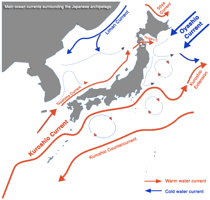
Eight distinct oceanic currents affect the islands of the Japanese archipelago.
they can be classified into 2 major north-flowing warm water currents, and 2 major south-flowing cold water currents.
WARM WATER CURRENTS (South>North)
The Kuroshio Current (黒潮, Kuroshio, literally “Black Current”, named after the deeper blue colour of its waters), and is also known as the Japan Current.
The Kuroshio is a warm water, north-flowing current, which transports warm, and tropical water northward toward the polar region.
It is by far the most important current affecting the Japanese archipelago, where it flows along the west side of the Ryū-Kyū islands, then, passing through the Tokara Strait, along the east coasts of the islands of Kyūshū, Shikoku and Honshū. The Kuroshio branches out into the following currents:
The Kuroshio Extension, which is the name given to the Kuroshio as it branches east in the Pacific, where it meets the southwards flowing Oyashio Current. We will look into the Kuroshio-Oyashio current system in further detail here.
Kuroshio Countercurrent, which flows southward to the east of the main Kuroshio Current, in the Philippine Sea, roughly 700 km off the coast.
Kuroshio Visualisation by NASA’s Perpetual Ocean Project
An overview of the 8 major currents affecting the Japanese archipelago
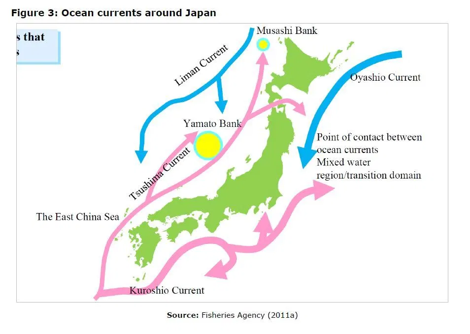
The Tsushima Current (対馬海流, Tsushima Kairyū) is a secondary branch of the Kuroshio Current flowing along the west coast of Japan. It splits from the Kurushio near Kyūshū, flowing northwards along the west coasts of Kyūshū and Honshū, through the Tsushima Strait (which gives it its name) and into the Sea of Japan. The Tsushima Current itself then branches out in two other currents:
The Tsugaru Current (津軽暖流, Tsugaru Kairyū) is formed when the Tsushima Current, flowing northwards up the Sea of Japan, divides in two branches. The Tsugaru Current is the branch flowing through the west entrance of the Tsugaru Strait, between the islands of Honshū and Hokkaidō
The Sōya Current (宗谷暖流, Sōya Kairyū), is formed by the branch of the Tsushima Current flowing along the north coast of Hokkaidō, and into the La Perouse Strait between the island of Sakhalin and north Hokkaidō. This current has a relatively stronger flow in the summer than in the winter.
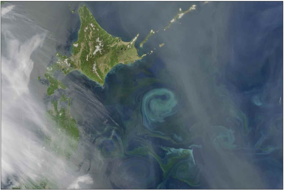
A swirling phytoplankton bloom is visible from space as the warm waters from the Kuroshio current collide with the frigid waters of the Oyashio current off the eastern coast of the main islands of Japan.
The Oyashio Current (親潮 Oyashio lit. “Parental Current” named for its metaphorical role as the parent 親, oya, providing for and nurturing marine organisms through its nutrient-rich waters), is also known as the Kurile Current.
The Oyashio is a subarctic, cold-water oceanic current, originating in the Arctic Ocean. It flows southward via the Bering Sea, passing through the Bering Strait and into the Sea of Okhotsk.
The Oyashio then flows along the east coast of Hokkaidō down to the North Pacific Ocean, along the northeastern coast of Honshū, where it collides with the Kuroshiocurrent’s Kuroshio Extension, and forms the eastbound North Pacific Current.
The Liman Current (リマン海流, LimanKairyū) is another cold current flowing southward between the island of Sakhalin and the Asian mainland, carrying colder water from the Sea of Okhotsk into the Sea of Japan.
A closer look at the Kuroshio-Oyashio system
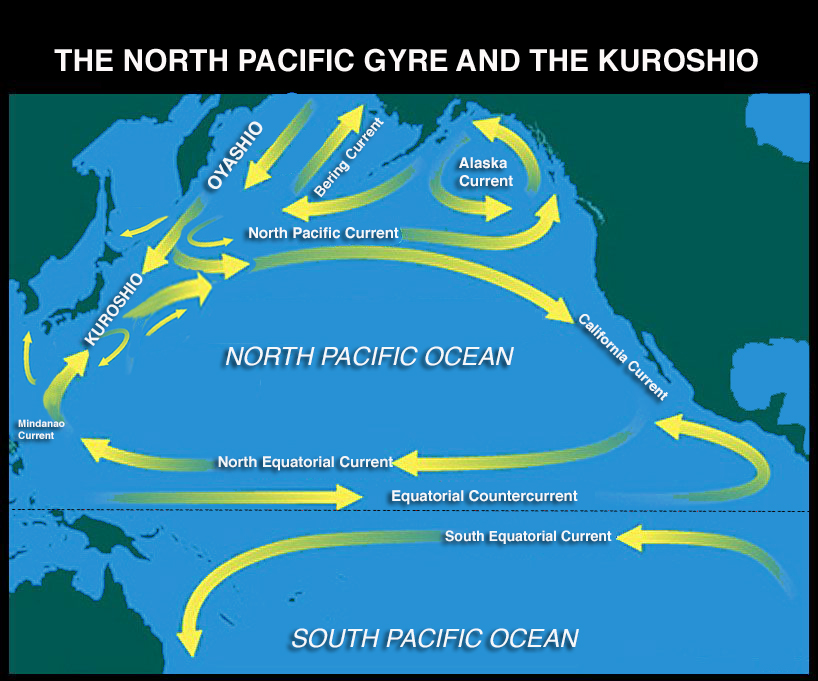
The Kuroshio (“Black Current”, the after the deeper blue colour of its rich waters) or Japan Current is by far the most important current affecting all the islands of the Japanese archipelago. To summarise its movement, the current constitute the western, subtropical boundary section of the clockwise flowing North Pacific Ocean Gyre.
The Kuroshio primarily forms off the coast of the Philippines, from where its powerful warm water flow northwards towards the Japanese islands, first along long the west side of the Ryū-Kyū islands, then, after crossing the Tokara Stait, primarily along the east coasts of the islands of Kyūshū, Shikoku and Honshū.
As it reaches the northern part of Honshū Island, the Kuroshio then meets a cold current, the Oyashio (or Kurile Current) that flows southward from the Okhotsk Sea, and this collision forms a highly productive, life supporting-mixture of warm and cold waters. The main flow then merges and feeds into with the eastern flow of the North Pacific Current.
The Kuroshio Current is one of the largest and strongest ocean currents in the world, flowing 2 to 4 knots on average. It can be considered as the Pacific Ocean’s equivalent of the Atlantic Ocean’s Gulf Stream, in that both currents transport the ocean’s warm, tropical and nutrient rich waters northward, up towards the Polar Regions, with a crucial effect on regional climate and human activities.
Indeed, the Kuroshio has huge influence on the ocean conditions and marine life of Japan. It is largely because of the multiple effects Kuroshio current flow that the waters surrounding Japanese islands count among some of the most productive and diverse regions in the world in terms of marine life, which is great for the fishing industry, but also for more contemplative activities such as scuba-diving, to which it gives warm and clear waters, coral and biodiversity.
Looking at the path of this important current in more detail, the Kuroshio finds its origins in the Pacific North Equatorial Current, which first runs westward along the Equator, passing through the east side of the biodiverse Coral Triangle.
The current then starts turning northward, and flows along the east side of the northern Philippines islands, where it is known as the Mindanao Current. The Kuroshio proper forms as it heads along the east coast of Luzon in the Philippines.
The flow then heads frankly north as it heads up the eastern coast Taiwan, before entering the East China Sea following a deep trench in the Ryū-Kyū island chain known as the Yonaguni Depression.
The Kuroshio continues heading northwards, flows along Japan, first on a course parallel to the west coasts of the Ryū-Kyū islands, following the Okinawa Trough, which is the deepest part of the East China Sea.
As it reaches the northern Ryū-Kyū’s Tokara islands, the main flow of the current heads east, and re-enters the Pacific by passing through a gap known as the Tokara Strait, which greatly increases its strength.
A slightly weaker branch of the Kuroshio, called the Tsushima Current, heads west and enters the Sea of Japan off the island Kyūshū, and continues flowing northwards along the western coast of Honshū.
The main Kuroshio Current (the Kuroshio Hon-ryū, or main current) flows along the east coast of Japan, meandering significantly, and notably hitting the Nanpō Archipelago’s Izu islands with considerable force.
As it reaches the vicinity of latitude 35°N, roughly near Kantō’s Bōsō Peninsula (which forms the eastern edge of Tokyo Bay), the bulk of the Kuroshio finally distances itself from the east coast of Japan and follows a more eastward course, in a segment known as the Kuroshio Extension.
The Kuroshio Extension then flows right into the southward-flowing Oyashio(“Parental Current”, named its metaphorical role as a parent, nurturing marine organisms) or Kurile Current, which is a cold subarctic ocean current originating in the Arctic Ocean.
The Oyashio itself circulates counter clockwise in the western North Pacific Ocean, transporting colder polar water into the Sea of Okhotsk and the Pacific Ocean.
As it flows south along the east coast of Japan, it collides with the Kuroshio Current off the eastern shore of Honshū.
Between longitudes 155° and 160°E, a considerable amount of the main flowturns south and southwest. This flow forms the main part of the Kuroshio countercurrent, which flows southward to the east of the main Kuroshio Current, in the Philippine Sea, approximately 700 km from the coast.
The main flow created by the encounter with the Oyashio forms the North Pacific Current (also known as the North Pacific West Wind Drift), which heads back east, towards the coasts of North America losing force west of the Hawaiian Islands.
While some of the original flow continues east to split off the coast of Canada and form the Alaska and California currents, the bulk of the flow joins the west-flowing Pacific North Equatorial Current to the south, directing warm water back towards the Philippines, in a clockwise flow that completes the cycle of the North Pacific Ocean gyre.
Kuroshio-related phytoplankton bloom off the coast of Honshū
Kuroshio-related phytoplankton bloom off the coast of Hokkaidō
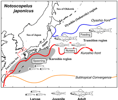
Many species, like the winter spawning Japanese Flying Squid (Todarodes pacificus) are entirely dependent on the flow of Kuroshio Current, and sometimes nicknamed Kuroshio Species.
The eggs and larvae of this squid develop in the East China Sea during winter months, after which adults population use the Kuroshio Current to travel, with minimum energy, to their rich northern feeding grounds located near northwestern Honshu and Hokkaidō.
Similar to the Atlantic’s Gulf Stream in its mode of creation and flow patterns, the Kuroshio has an important warming effect upon the south and southeast coastal regions of Japan, as far north as Tōkyō.
Another indirect effect of the Kuroshio-Oyashio current system is the creation of powerful coastal upwellings, which, combined with Japan unique and complex, mostly volcanic based underwater topography, will bring deep-sea dwelling organisms up with the water.
Off the coasts of Japan, as the warm waters (the current has surface temperature of 24°C on average) of the powerful Kuroshio and the colder waters the Oyashio collide, a layer of nutrient-rich water is brought to the surface, where the water movement creates strong turbulent circular currents called eddies.
Phytoplankton growing in the surface waters become concentrated on the borders of these eddies, following the swirling motions of the water.
As a result of this complex water circulation, the zooplankton communities in the boundary waters are unique and diverse, which greatly boosts marine populations. Kuroshio-specific marine life has long supported Japan’s extensive fisheries, on both coasts of the archipelago.
Possible spawning migrations of Notoscopelus japonicus in relation to currents
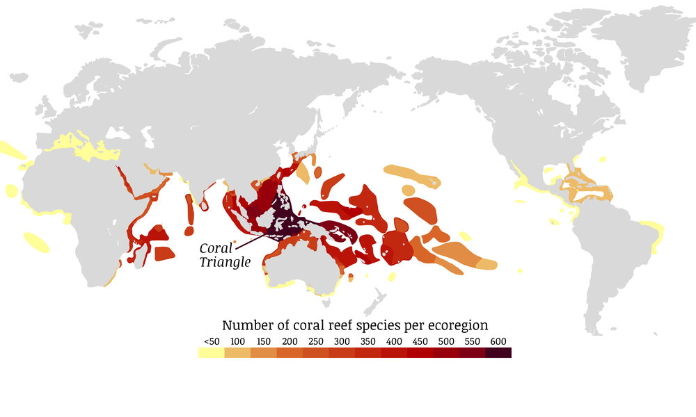
The Kuroshio Current originates from within an area called the Western Pacific Warm Pool, and flows through parts of South-East Asia’s Coral Triangle, in other words, through one of the world’s major marine biodiversity centres, before heading northwards towards the islands of Japan. This is one of the reasons why the Ryū-Kyū Island’s coral reefs form one of the worlds’ richest centres of multi-taxon endemism, with a great coral diversity.
Coral reef species per ecoregion, highlighting the influence of the Kuroshio current on Japan’s coral reefs
The warm waters of the Kuroshio Current also sustain diverse coral reefs across Japan, which develop at higher latitude than elsewhere.
These reefs include the recently discovered cold water shallow coral colonies of Tsushima Island, in the Korea Strait between mainland Japan and the Korean peninsula, or those of Wakayama Prefecture in central Honshū, which are thought to constitute the northernmost, non-deep water coral reef ecosystems in the world.
While the Kuroshio Current is somewhat affected by the Monsoon cycle, it also has a direct influence local weather in Japan.
Since air temperatures tend to be controlled by heat in ocean surface waters, and the Kuroshio carries warmer water from south to north, current-transported heat often induces cloud formations, which increase the chance of rain and also changes the path of storms. During the winter season, for instance, if the Kuroshio takes a large meander, low-pressure zones will shift southward near Honshū Island, which will increase the chance of snowfalls in Tokyo.
The Kuroshio Current exhibits distinct seasonal fluctuations, and its path off the coasts of Japan is reported every day (see Kuroshio Watcher, a website in Japanese aimed at operators of the fishing industry). The current is strongest from May to August. Receding a little in late summer and autumn, its flow begins to increase gradually from January to February only to weaken again in early spring, which greatly affects water temperatures, an important factor for fishermen and… scuba divers.